Drone Survey
Thermal survey
A radiometric thermal camera flown over a building to show where heat is leaving it and where moisture is sitting, which an ordinary camera cannot show.
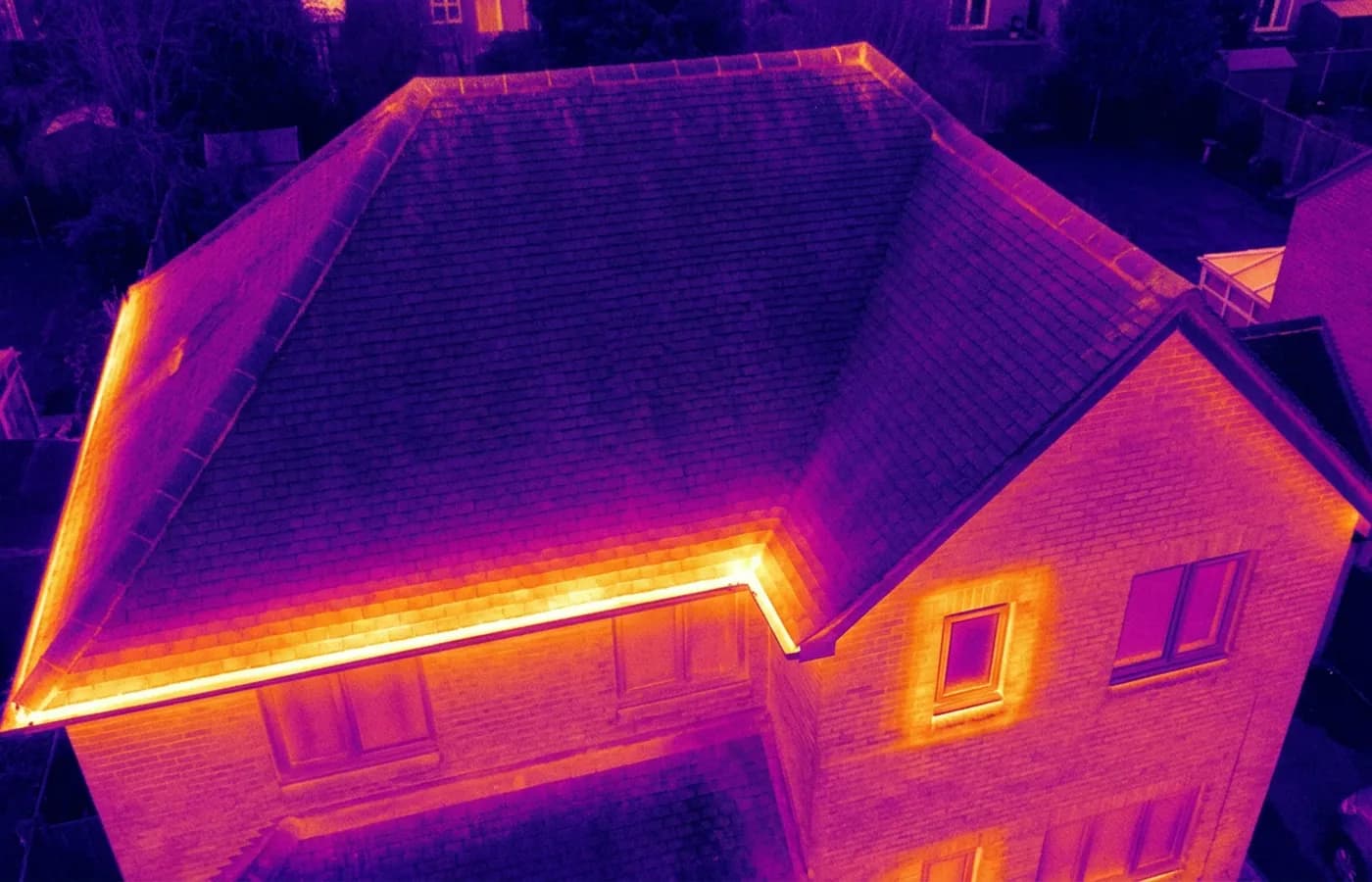
The second aircraft carries a 640 by 512 radiometric thermal camera alongside the ordinary one. It does not see through anything. What it records is the temperature of the surface it is pointed at, and the pattern those temperatures make is what carries the information.
That pattern is useful in two situations. Heat leaving a building shows up as a warm area where the insulation is missing, thin or has slumped inside a cavity, which an ordinary photograph cannot show at all. And moisture, because a wet part of a roof or a wall holds and releases heat differently to the dry part beside it, so a damp patch under a membrane often appears as a shape long before it appears as a stain indoors.
It is more conditional than the other two jobs. A thermal survey needs a temperature difference between inside and outside to show anything, so it is winter work, flown early or after dark, and a mild afternoon in June will produce a picture with nothing in it.
What is included
- Thermal imagery of the roof and the elevations that can be flown
- A matching ordinary photograph of each thermal frame, so the shapes can be placed
- A note of the conditions, because they decide what the images mean
- Interpretation in plain words, with the uncertain ones marked as uncertain
- The radiometric files as well as the images
- Delivered within 48 hours of the flight
What a thermal image is actually showing you
Surface temperature, and nothing else. Every conclusion drawn from it is an inference about why one part of a surface is warmer than another, which is why the conditions on the night matter as much as the camera does.
Sunshine earlier in the day is the usual complication. A roof slope that has had afternoon sun on it holds that heat for hours and will read warm regardless of what is underneath, which is exactly why these flights happen before dawn or well after dark. Wind and rain both flatten the picture too, by carrying heat away evenly across a surface.
A report that skips those conditions is not worth much. Two identical images taken on different nights can mean opposite things, so the conditions are recorded alongside the imagery every time.
Heat loss, and what people do with it
On a house, missing or slumped insulation shows as a clear warm area against a cooler field, and the shape of it usually says what happened: a band along the eaves where the loft insulation stops short, a rectangle where a hatch or a downlight breaks the layer, a stripe following a rafter or a joist.
That is worth having before you spend money on insulation, because it puts the work where the loss is instead of everywhere. It is also worth having afterwards, for the same reason in reverse.
Moisture, and why it is the harder read
Wet material behaves differently to dry material as everything cools down overnight, so on a flat roof a saturated area under the membrane often appears as a soft warm shape with no edges. That is frequently the first sign anybody gets that a flat roof is holding water, well before it shows up on a ceiling.
It is also the read most easily got wrong. Plant, standing water on the surface, a warm room underneath, a recent repair in a different material: all of them can produce a similar shape. Where a thermal image suggests moisture, the report says what would confirm it, which is usually somebody on the roof with a meter or a core.
On the day
How a thermal runs
- Step 1
Pick the conditions, not the date
A useful thermal survey needs a real temperature difference between inside and outside. That means the cold half of the year, and usually before sunrise or after dark, so the date follows the weather.
- Step 2
Heat the building normally
The heating on as it usually is for several hours beforehand. Nothing special, just not a house that has been empty and cold for a week.
- Step 3
Fly both cameras
The thermal and the ordinary camera over the same passes, so every heat pattern has a matching photograph to place it against.
- Step 4
Interpret carefully
A warm patch has more than one possible cause. The report says which are likely, which are not, and which need something else to confirm them.
Behind the work
Kit, cover and qualifications
CAA registered
Registered with the Civil Aviation Authority as an operator, with both an Operator ID and a Flyer ID held. Anybody flying a camera drone for you should hold both.
A2 Certificate of Competency
The qualification that covers flying closer to buildings and to people than the basic rules allow. It is not a GVC and this site does not claim one.
Insured with Coverdrone
Commercial flights are covered by a Coverdrone policy. A copy of the certificate is available on request, and most managing agents will ask for it.
One named surveyor
Sam Hembury plans and flies every job himself and writes up every report. There is no crew and no subcontractor, so the person you speak to is the person who turns up.
DJI Mavic 4 Pro
A 100 megapixel Hasselblad camera and 6K video. That resolution is the reason a cracked mortar joint is readable in a photograph taken from twenty metres away.
DJI Mavic 2 Enterprise Advanced
Carries a 640 by 512 radiometric thermal camera alongside the ordinary one, which is a different job: heat and moisture rather than condition.
Report within 48 hours
The written report follows the flight within 48 hours. It is a process commitment rather than a promise about what the report will find.
Construction background
The reports are written by somebody who worked in construction before flying, so a defect is described in the words a builder or a roofer will use back to you.
Thermal
Thermal survey questions
- Can you do a thermal survey in summer?
- It can be flown, but it will usually show very little. Without a real temperature difference between inside and outside there is nothing for the camera to separate, so these flights are booked for the cold half of the year.
- Does the thermal camera see through the roof?
- No. It measures the temperature of the surface it can see. Everything useful comes from reading the pattern those temperatures make, which is a different thing from seeing inside.
- Do I need the heating on?
- The building should be heated as it normally is, for several hours before the flight. That is what creates the difference the camera reads. Nothing else needs doing.
- Will it find a leak?
- It will often show where water is sitting, which is usually a long way from where it comes through a ceiling. That is worth having, but it points at an area to investigate rather than settling the cause on its own.
Where
Thermal survey across the South West
Also on this site
See what it costs
Get a quote with Drone Survey
Tell us the address and what you need looking at. Sam Hembury will come back with a fixed price and the next available slot.