Drone Survey
Land and site survey
A field, a yard, a paddock or a development plot photographed from directly above and stitched into one flat image, so an area can be seen and shared.
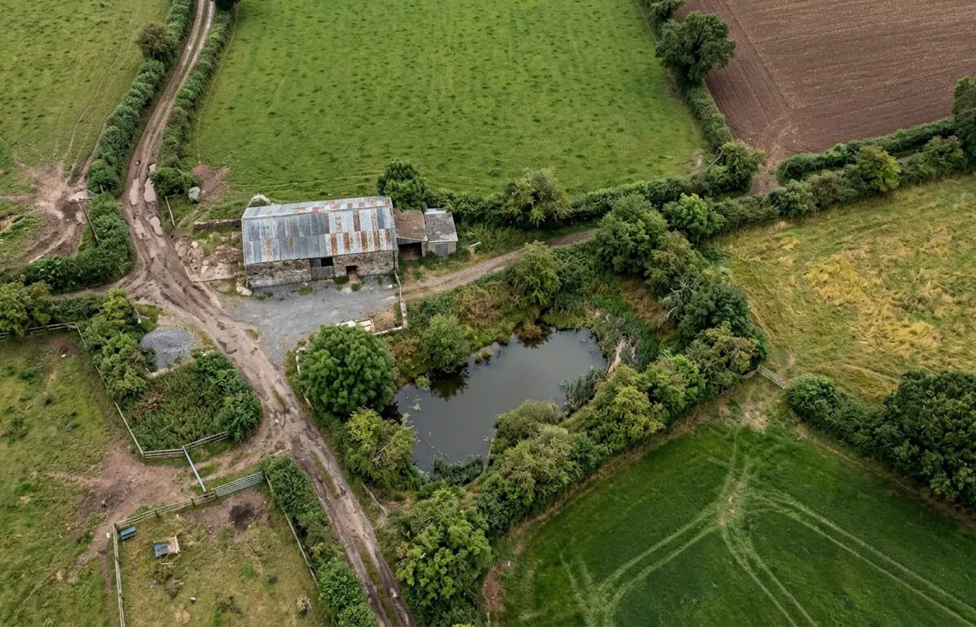
This is the same aircraft doing a different job. Instead of working round a building, it flies a grid over an area at a set height and takes overlapping photographs on a fixed interval. Those get stitched into one flat, map-like image of the whole parcel.
People ask for it when they need to show an area rather than describe it: a plot going through planning, a farm working out what is where, a site owner recording the state of the ground before works start, or anybody in an argument about a boundary who would rather have a picture than a memory.
It is worth being clear about what this is not. A stitched aerial image is not a land surveyor's plan and it does not carry surveyed accuracy unless somebody has put control points on the ground and tied it to them. For anything legal or anything being built to, that control is the missing piece and a land surveyor supplies it.
What is included
- A flown grid over the agreed area with overlapping frames
- One stitched, flat overhead image of the whole parcel
- Oblique photographs from each corner for context
- A note of the date, the conditions and the area covered
- The original frames as well as the stitched result
- Delivered within 48 hours of the flight
Why an overhead image beats a description
Land arguments are almost always about position. Where the track runs, how far the hardstanding reaches, which side of the hedge the ditch is on, how much of the field is under water in February. All of those are trivial to see from directly above and painfully hard to describe in a sentence.
The other value is the date. A parcel of land changes with the season and with whoever is working it, so an image with a date on it settles what the ground looked like at a particular moment. That is worth having before works start, before a tenancy ends and before anybody digs anything.
Where the real limit sits
Stitched aerial imagery gives you shape, position and relative distance to a standard that is fine for planning discussions, for showing a contractor the site and for having a sensible conversation about layout. What it does not give you on its own is a figure you can build to or defend in a dispute.
That comes from ground control: fixed points measured on the site and tied into a national grid, which is a land surveyor's work. Where a job needs that, this site says so rather than quoting a number that would not survive being checked. Plenty of jobs do not need it, and the ones that do are usually the ones where somebody has already said the word tolerance.
The kinds of ground this suits
Farmland, paddocks and grazing. Yards, hardstanding and storage areas. Development plots before and after clearance. Large gardens and grounds where a plan has never existed. Anything with a boundary somebody is asking questions about.
It suits open ground much better than tree cover. A canopy hides what is under it, so woodland reads as a green surface rather than as ground, and any figure taken across it would be measuring the tops of the trees.
On the day
How a land and site runs
- Step 1
Agree the boundary
On a map, before anything is flown. Whether the flight covers the hedge line, the far side of it or the access track changes the height, the time and the price.
- Step 2
Check what is above it
Open farmland is straightforward. Anything near an airfield, a mast, a power line or a public road needs planning first, and that is done before a date is offered.
- Step 3
Fly the grid
Set height, set interval, overlapping passes. A predictable pattern is what makes the frames stitch cleanly afterwards.
- Step 4
Stitch and deliver
The frames are processed into one overhead image, checked against the obliques, and sent with the originals.
Behind the work
Kit, cover and qualifications
CAA registered
Registered with the Civil Aviation Authority as an operator, with both an Operator ID and a Flyer ID held. Anybody flying a camera drone for you should hold both.
A2 Certificate of Competency
The qualification that covers flying closer to buildings and to people than the basic rules allow. It is not a GVC and this site does not claim one.
Insured with Coverdrone
Commercial flights are covered by a Coverdrone policy. A copy of the certificate is available on request, and most managing agents will ask for it.
One named surveyor
Sam Hembury plans and flies every job himself and writes up every report. There is no crew and no subcontractor, so the person you speak to is the person who turns up.
DJI Mavic 4 Pro
A 100 megapixel Hasselblad camera and 6K video. That resolution is the reason a cracked mortar joint is readable in a photograph taken from twenty metres away.
DJI Mavic 2 Enterprise Advanced
Carries a 640 by 512 radiometric thermal camera alongside the ordinary one, which is a different job: heat and moisture rather than condition.
Report within 48 hours
The written report follows the flight within 48 hours. It is a process commitment rather than a promise about what the report will find.
Construction background
The reports are written by somebody who worked in construction before flying, so a defect is described in the words a builder or a roofer will use back to you.
Land and site
Land and site survey questions
- Can you measure the area for me?
- An area can be taken off a stitched image and it will be close, and for a conversation about layout that is usually enough. If the number has to hold up in a contract or a dispute, it needs ground control and a land surveyor, and the report says that plainly.
- How big an area can be covered in one visit?
- That depends on the height flown, the shape of the parcel and the weather window. It is worked out at the quote stage from the boundary on a map, so the price reflects the actual site rather than an average one.
- Can you fly over land I do not own?
- Flying is governed by aviation rules rather than by land ownership, but the sensible answer is that flights are planned around the site being surveyed. If a neighbour's ground has to be crossed to reach it, that gets discussed first.
- Does the grass height matter?
- For an image of the surface, no. For anything about the ground under it, yes: long grass, standing crops and bracken all hide what they are growing on, so timing a flight for a shorter sward is worth doing.
Where
Land and site survey across the South West
Also on this site
See what it costs
Get a quote with Drone Survey
Tell us the address and what you need looking at. Sam Hembury will come back with a fixed price and the next available slot.